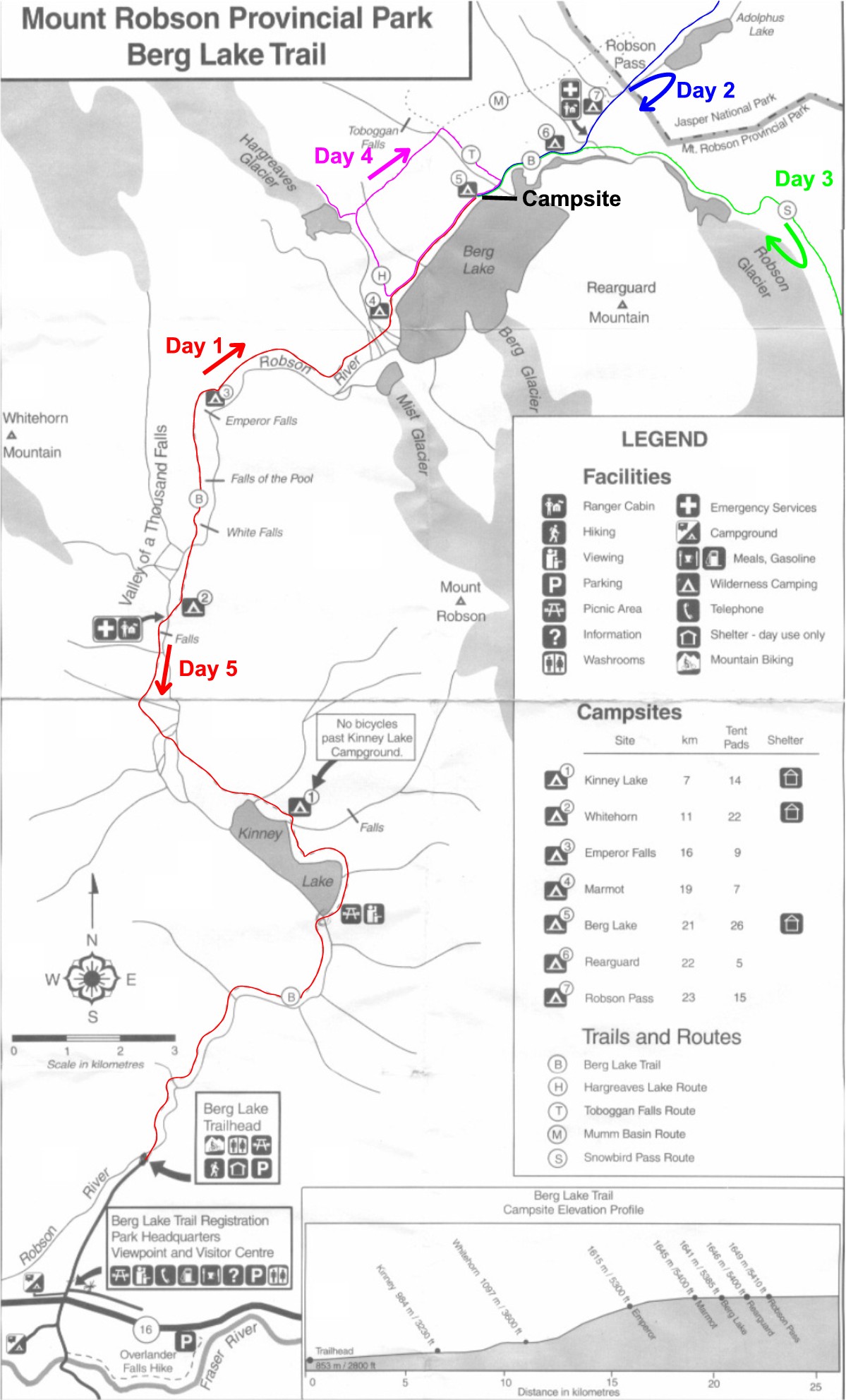
Here you see a map of the trail and the surroundings. I have indicated our hikes on the map. Below it is a description of the hike. Both the map and the description are taken from “The Canadian Rockies Trail Guide” by Brian Patton and Bart Robinson.
Berg Lake
Robson River Parking Area to Kinney Lake—4.2 kilometers (2.6 miles)
Robson River Parking Area to Berg Lake—17.4 kilometers (10.8 miles)
Backpack
Allow 8-10 hours to Berg Lake
Elevation gain: 790 meters (2,600 feet)
Maximum elevation: 1638 meters (5,375 feet)
Point of Departure: Drive the Yellowhead Highway to the Mount Robson service center, 58 kilometers (36 miles) west of the Alberta-B.C. Boundary (Yellowhead Pass). Take the dirt road which cuts off to the north (by the service station) and follow to its terminus at the Robson River parking area, approximately 2.5 kilometers distant.
Trail description:
0.0—Robson River bridge.
4.2—Kinney Lake (outlet bridge). Campsite.
4.5—Kinney Lake (shore viewpoint).
6.1—Avalanche area.
6.9—Junction. Foot trail stays to right.
8.2—Robson River and bridges. Outwash flats above Kinney Lake.
10.3—Suspension bridge over Robson River.
10.5—Campground.
11 3—Suspension bridge over Robson River. Steep switchbacks begin.
11.8—White Falls viewpoint.
12 7—Falls-of-the-Pool viewpoint.
14.3—Emperor Falls (200 meters to right).
15.0—Campsite. Trail flattens out.
16 9—Outwash stream and bridges.
17.4—Berg Lake (northwest shore).
19.3—Berg Lake Chalet.
19.6—Campsite.
20.9—Warden Cabin.
21.6—Shelter and campsite.
21.9—Robson Pass. Alberta-B.C. boundary.
“On every side the snowy heads of mighty hills crowded round, whilst, immediately behind us, a giant among giants, and immeasurably supreme, rose Robson’s peak… We saw its upper portion dimmed by a necklace of light, feathery clouds, beyond which its pointed apex of ice, glittering in the morning sun, shot up far into the blue heaven above.”
So reflected Viscount Milton and W.B. Cheadle, two young British adventurers who passed Mount Robson on their way from Jasper House to Tete Jaune Cache in 1863. One can only tremble to think to what heights their prose might have risen had they journeyed via Robson Pass and Berg Lake, beneath the awesome, ice-bound north wall of the highest peak in the Canadian Rockies. There can be little dispute that this area is one of the gems of the mountain world. There is even less doubt that it is the most heavily traveled backpacking trail in the mountain parks.
From the trailhead parking area, the trail climbs gradually along the torrent of the Robson River and through a micro-rain forest of Douglas fir, cedar, spruce and hemlock. The lush forest, which is very out-of-place in the Rocky Mountains, is in part created by Mount Robson. Rather than spreading over the broader hand of the Rockies, as is usual, rain concentrates in this valley when Pacific weather systems run afoul of this huge mountain.
Kinney Lake, located 4.2 kilometers from the trailhead, is an excellent example of a glacially fed lake. Its waters are milky blue, the result of great quantities of finely ground rock material fed into the Robson River by glaciers on Mount Robson and its neighboring peaks. The lake is named for the Reverend George B. Kinney, a Canadian mountaineer who made the first attempts to scale Mount Robson in 1907, 1908 and 1909.
From the southeast end of Kinney lake the trail is not so easy as before. It ascends a short series of switchbacks and traverses above the northeast side of the lake, just a little warm-up for the rigors ahead.
At Kilometer 6.1 the hiker comes upon an extraordinary scene of devastation. In the early spring of 1968 a spectacular avalanche rolled down from the western slopes of Mount Robson. In its wake huge cedar trees have been left splintered and crushed. Many of these once magnificent trees are still standing, but their tops have been snapped off thirty or more feet above the ground.
At Kilometer 7.2 there is an excellent view of Kinney Lake and the gravel outwash area at its head. The waters of the Robson River deposit rock and silt over the valley floor creating an outwash plain. The hiker has an opportunity to examine the phenomenon at closer quarters when he crosses the broad flats at Kilometer 8.2.
After a short steep climb up from the Kinney Lake outwash flats and two more crossings of the Robson River on suspension bridges, the trail begins it tortuous rise up the spectacular Valley-of-a-Thousand Falls. In the next 3.5 kilometers the hiker climbs over 450 vertical meters, ascending near the narrow gorge which contains the thundering Robson River. Three major waterfalls are viewed on the ascent-—White Falls, the Falls-of-the-Pool and Emperor Falls.
After leveling off above the Valley-of-a-Thousand Falls, the trail dips down along the river again, offering the first glimpse of the majestic, snow-crusted north wall of Mount Robson. Views of the wall and its glaciers become increasingly spectacular beyond.
The view across the powder-blue waters of Berg Lake to Mount Robson is exceptional to say the least. Two rivers of ice cascade down from the uppermost reaches of the mountain—Mist Glacier and Berg Glacier. The latter terminates in the lake. The groan and rumble of these two overburdened bodies is constant, with chunks of ice calving from Berg Glacier and drifting into the lake.
The summit of Mount Robson lies more than two vertical kilometers above the lake, at an elevation of 3854 meters above sea level. First climbed in 1913 by a party led by Conrad Kain, it has been the object of many subsequent expeditions and is still considered one of the most difficult ascents in Canada. The mountain also contains the greatest section of Cambrian rock known in Canada—some 400 meters thick.
Robson Pass lies just over two kilometers beyond the northeast end of Berg Lake and serves as the gateway to the remote northwest corner of Jasper National Park. The trail runs through the pass to Adolphus Lake and the Smoky River valley beyond. There are three campsites in Robson Pass vicinity: the first and most popular lies just beyond Berg Lake Chalet along the edge of the lake’s broad gravel beach: another provincial park campsite is situated on the open flats just 300 meters west of the pass: and there is a more secluded national park campsite just over a kilometer east of Adolphus Lake. As of this writing, future accommodation or services at Berg Lake Chalet are doubtful.
There are a number of interesting explorations which can be made by hikers staying in the Berg Lake-Robson Pass vicinity. The toe of the Robson Glacier can be visited in an easy half-day trip and there are routes leading up from the chalet area to the open slopes below Mumm Peak that offer outstanding aerial views of Berg Lake and Mount Robson. More energetic souls can backpack further into the wilderness by continuing into Jasper Park along the North Boundary Trail for another day to Chown Creek; there are short but interesting side trips which can be made up both Mural Creek and Chown Creek along the way.
Those planning a trip to Berg Lake should consider, however, an entry in the journal of J.M. Sellar, who traveled down the Fraser River in 1862: “…the guide told us that out of twenty-nine times that he had passed it (Mount Robson) he had only seen the top once before…”